In the Beginning - As a Stone Quarry.
Towards the end of the 16th century, Liverpool was a growing town. It’s importance as a seaport had not yet been realized. Raw materials were being brought into the town from the surrounding area. Several quarries supplied the infant town with sandstone for building. Two within close proximity to each other near the present Brownlow Hill, one near to the present Park Road and the largest being that at the top of the present Upper Duke Street.
Quarrymen had excavated a chasm stretching from the top of present day Rodney St. to Parliament St. Stone from here was supplied to builders of some of old Liverpools finest buildings. The Town Hall and the Docks being examples.
Even back then local ‘oppertunists’ saw their chance. The following was recorded in Liverpool Town Books, 1572:
John Knollis supplied the stone (ashlar) to others. We present fineable John Knollis for getting ashlar stones in the quarrell, not having license of mayster maior and his brethren.
Mr. Knollis gets quite a few mentions in the Town Books. It was illegal to quarry stone without a licence from the Mayor. In June 1628 in a session before the Mayor, Edward Blanchard, it was reported:
Item wee present Thomas Baxter of Wavertree for gettinge of stones upon the quarrel hill without Lycence from Mr. Maior. Item wee present Thomas Graice of Wavertree for the like. Item wee present James Newton for gettinge of stones upon the hill and filleinge up the delph with Rubbysh.
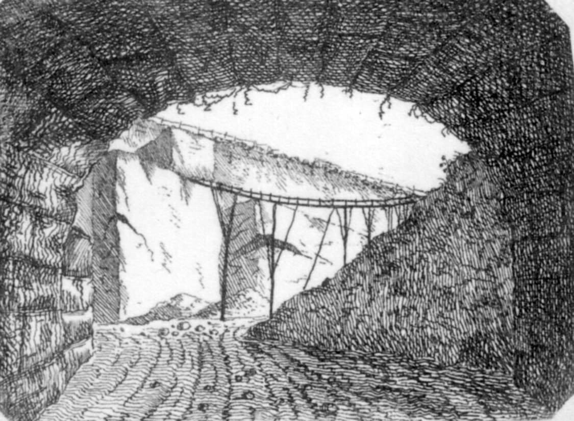
This picture has been very kindly supplied by Don Higham, and shows the working quarry from inside one of the tunnels. Some sort of structure seems to be in place to move stone around, evidence of this is still apparant on the stone walls.
There certainly appears to be some sort of track marks in the ground, the remaining walls of the quarry show evidence of something having been scraped against it, possibly some sort of vehicle for transporting stone.
The two ends of the quarry appear to have been covered to create two tunnels “cut and cover” and work proceeded towards the South.
In this 1773 drawing by Nicholson, you can again see evidence, in the tracks on the ground, of this ‘vehicle’ moving, this time through the other tunnel.
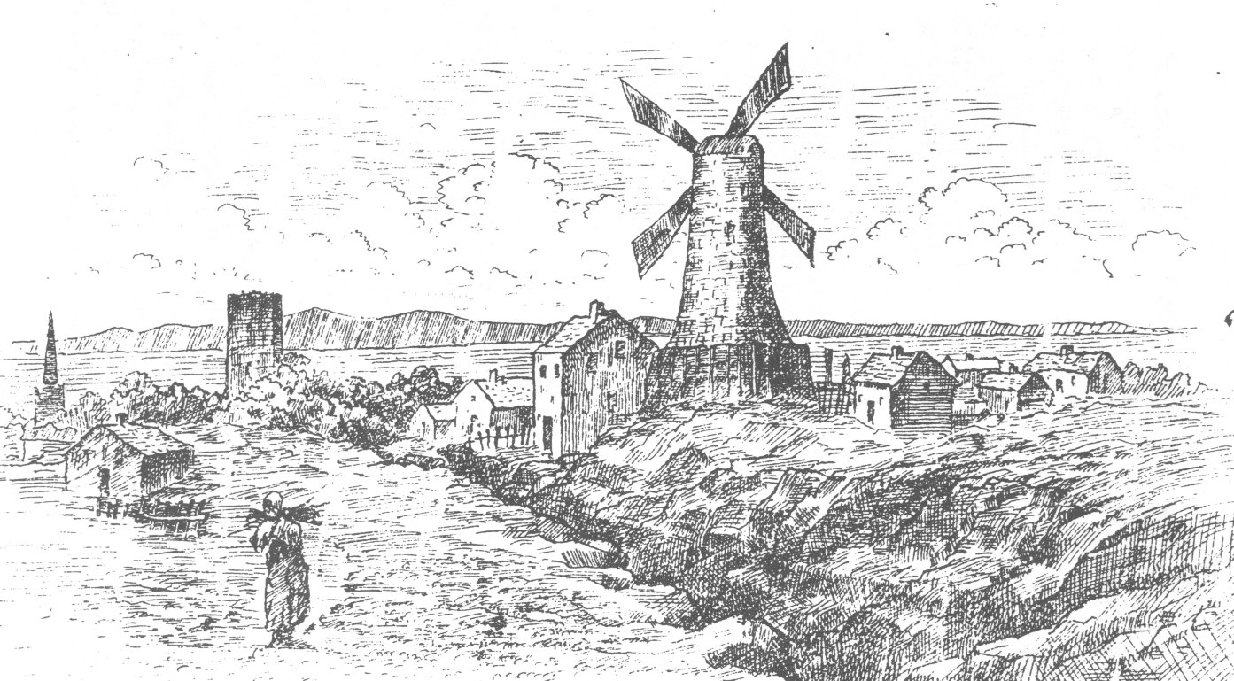
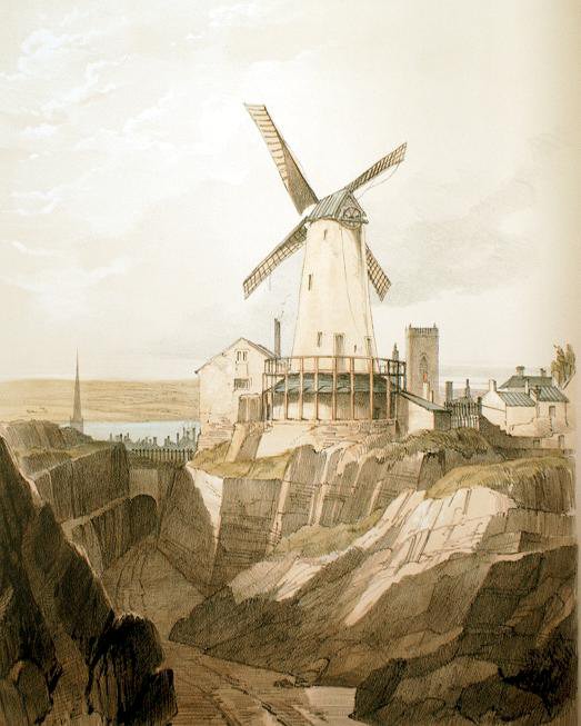
This Windmill stood on the site of the present Oratory and was demolished after storm damage in 1796. There is still evidence of its existance in the area around the Oratory.
St James Mount
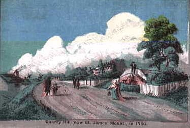
To the West of the quarry stood a natural hill, known as Quarry Hill, or locally as Mount Sion (Zion.) Across this hill there was a walkway, which presented some fine views of the growing town. In 1753, under the direction of Alderman Trafford, Mr. Poole and Mr. Bailiffe Cunliffe, it was ordered that:
The walk be gravelled and repaired, and a foot walk be made up so as not to neglect the townsfolk’s interests
A year later part of the land was turned over to the Crown and a 14 gun battery was constructed.
Between the years 1767 - 68, due to very high levels of unemployment in the town, the Mayor, Sir Thomas Johnson made use of the idle labour force to construct an embankment on the mount. ON december 7th 1768 it was recorded that:
John Bridge to have liberty to enclose, and take in a piece of ground to the south and eastward of his house on Zion Walk on Quarry Hill Wast according to the plan now produced, and to take down the present powder magazine and watch house, and rebuild the same in some other convenient place as shall be fixed by the Mayor,(William Gregson) and to convert the said land into a bowling green.
The idea of a ‘public walk’ or recreation ground gave birth to the idea of a public park. In 1771 the Mayor, John Sparling, ordered that:
John Callander to be allowed the sum of £20 per year to look after, and take care of the walk, and to find all trees, gravel and labourers to maintain the standard of the walk.
Today, the pathways and stone steps are pretty much the same as what john Callander laid out over 200 years ago.
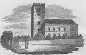
In the year 1775 the Church of St James was completed on the neighboring Parliament Street. In recognition of this it was decided to rename Quarry Mount to St James’s Mount. The drawing is by T. Troughton, dated 1780 it was a gift for the Rev John Smith, of St James Church.
Later on in 1775, Enfield wrote:
“Among the public places, the Terrace, at the fourth end of the town, called St. James's Walk, deserves to be particularly mentioned. It is upon an agreeable elevation, which commands an extensive and noble prospect, including the town, the river, the Cheshire land, the Welsh mountains and the sea. It is of a considerable length, and much improved by art. Behind this eminence is a stone quarry, which plentifully supplies the town for every purpose of building. Here labour has exposed to view one continued face of stone, 380 yards long, and in many parts 16 yards deep. The entrance to this quarry is by subterraneous passage, supported by arches; and the whole has a pleasing and romantic effect. There is found here a good chalybeate water, which appears upon trial to be little inferior to many of the spaws.”
In 1775 John Bridge opened the doors of The St James Coffee House. Taverns and Inns were very much part of life during the 18th century. In 1852, Brooke recalled of this establishment:
"A coffee house of considerable repute, kept by Mr. John Bridge, frequented principally by persons of a superior class, and where parties of gentlemen occasionally had dinners and other entertainment”
Fortunately, exactly what the ‘other entertainment’ was, has been lost with the passage of time!
A couple of menu’s from St James Coffee House can be seen by clicking Here
There were, however, those who believed that Mount Zion should be kept free from Taverns and the like. In 1779, Picton recorded the feelings of a local clergyman, who wrote the following:
"The Mayor and Council in a dreaming fit, To slight the Scriptures, and to show their wit,The name of Zion, sacred seat of heaven,To this unhallowed common walk have given,Fond of impiety, behold a shrine They've dedicated to the god of wine, And to excite our admiration more, See 'Bottled Beer' recorded o'er the door, But thou, who answerest the poor man's prayer, Protect the innocent and guard the fair,And if thou can forgive, forgive the Mayor!”
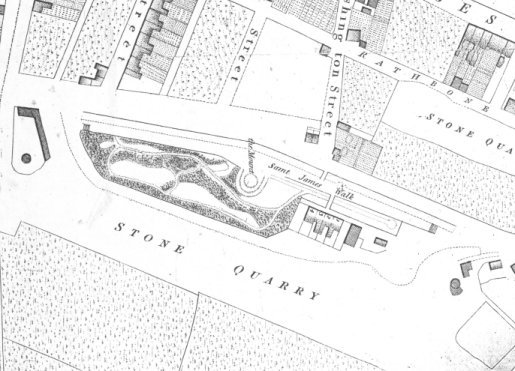
The beginning of the 19th century saw the quarry as a major landmark. The map to the right is by Horwood and clearly shows the excavation, as well as the properties on St James Mount. To the left (south) you can make out the windmill featured in the drawing by Sanders at the top of this page. As mentioned earlier the pathways have remained to this day. The centerpiece was the Mount itself, this was reported to be used as an astronomical observatory, and later as a photographic studio.
The windmill was demolished in 1821 after severe storm damage.
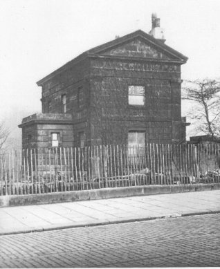
A lodge was built built for the gardeners at the end of the walk. This idea did not come to immediate fruition, although a temporary structure was built, it was left until 1826 until the lodge shown on the left was built. This picture was taken about 1934 and the lodge still stands today,as a private residence. There is still evidence of the windmill in the grounds.
As a Cemetery.
By the year 1825 the useful stone from the quarry had been exhausted and it was left to the town council to decide what was to be done with this huge scar left in the town. The corporation raised nearly £20,000 by public subscription and employed the young architectJohn Foster (1786 - 1846) to design and lay out a cemetery along the same lines of the Pere-la-Chaise, Paris. This new cemetery would relieve the pressure on the Low Hill Cemetery, Everton where it was getting difficult to prepare a new grave without disturbing another corpse.
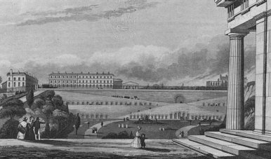
Through Foster's imaginative use of a unique site he created a cemetery of real dramatic grandeur. The East wall was transformed into a sequence of broad ramps, or walkways, lined with catacombs cut into the rock face. These led down to the burial ground itself, laid out with winding paths and lined with trees. On the high ground to the North-West, on the site of the old windmill, he built the Oratory (1827) and a house for the Minister. While at the South-West he provided a monumental arch and a porters lodge.
This picture is by W. Read and shows St James Cemetery from the North. In these drawings the people were drawn small to give everything else a sense of grandeur.
In 1829 Liverpool's new cemetery was consecrated by Dr. Sumner and the Bishop of the Diocese and the first interment took place, that of Mr John H Harem of Slater St, Liverpool, (thanks to Caroline Bunford for this snippet), apparently to the accompaniment of some of the worst thunderstorms for years!
During the Victorian era the cemetery was being filled at the rate of sometimes eight burials a day. Horse drawn Hearses came down the walkways bringing the great and small of old Liverpool to their final resting place.
The rich had their catacombs and vaults, while the poor were buried in pits, with a thin layer of soil on top at the end of the day, ready for the next days poor!
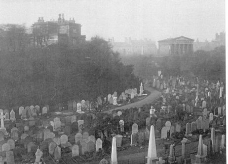
This photograph from about 1902 shows a crowded cemetery. To the top right the Oratory can be seen, while the ministers house can be seen to the left.
In 1894 a proposal was made that the cemetery should be filled in and the land set aside for other uses. This prompted a public outcry and Mr. T.W.Chritie wrote to Bishop Ryle:
"At last it is disclosed that not only have ye been nursing the plot in secret, but have actually passed a vote of thanks to Mr. Lister for his plan for filling up the cemetery from end to end. A monstrous and inhuman proposal to say the least of it.”
Fortunately this idea did not get off the ground. In 1900 the Bishop of Liverpool proposes the erection of a cathedral, and six different sites were considered. On the 17th June 1901 a public meeting was held at the Town Hall and as a result the site of St James Mount was decided upon. In 1903 the properties on the Mount were purchased for £11,300 and on the 19th July 1904 the foundation stone of Liverpool Anglican Cathedral was laid by King Edward VII and Queen Alexandra.
Burials continued until, after 57,774 burials, the old cemetery was considered full. Liverpool Corporation sent letters to those who owned plots within the grounds. Click here for an example. The last burial took place in July 1936 and the cemetery was officially closed. Sadly in the years after that it was left overgrown, with no security or care so it was not surprising when it fell into a state of disrepair. During the late 1960's it was decided that action was needed. A plan to turn St James Cemetery into a public garden was proposed. This involved clearing the vast majority of the gravestones and creating an open space. This was completed by 1972.
_____________________________________________________________________________________________________________________
Further Reading
Here I have provided links to some further information about the History of the cemetery.
1. Here are some Early maps and pictures
2. Liverpool Corporation document outlining the movement of Tombstones
3. An Extract from ‘A Strangers guide to Liverpool’ 1850
4. An Extract from 'The Liver’ 1830
_____________________________________________________________________________________________________________________
Page Last Updated